Saturday, December 15, 2012

Carretera Austral - Part 2

At half time in the trip down the Carretera Austral the score was Weather 3 - 1 Simon&Simon. It was not looking good for the boys from Europe until they pulled off an ambitious ascent of Cerro Castillo, to be rewarded with spectacular views and an extra-time glacier lake.


We had come from Coyhaique, the regional capital, which was little more than a place to stop off and get some provisions. There are no camping grounds but we managed to persuade one of the hostel owners to let us camp in their garden - another $2 saved! Even though Coyhaique is a big town, it is still in the middle of some beautiful countryside. I will never get bored of this.


The next morning we arrived in the tiny village of Villa Cerro Castillo, a one-road group of huts named after the striking Cerro Castillo (Castle Hill). It may be called a hill, but its jagged, spiny peaks stand at over 1,600m above sea level, and spend the whole year covered in snow.


The first thing we did was hit the information centre. The guy told us there were two routes, a 5hr hike without signs (not recommended) and a 7hr hike with signs. Those times are one-way, making the signed trail a two-day hike for most people. I decided that we would be fast enough to do the long hike in one day.

The day can only be described as epic - and not really in a good way. We set off at a blistering pace and got to the quarter point in good time. We then marched through the forest, which was largely uphill, until the halfway point. At this stage Simon had realised that he doesn't like hiking as much as I do and decided to stroll back to the campsite.


Time was running out so I practically jogged the next hour. Then disaster struck. I looked at the map (actually, a picture I had taken of a map) and realised that I had taken a different trail, walking 3km in the wrong direction. There was definitely no time to turn back and correct the mistake. There was only one thing for it - I left the trail, pointed myself uphill and crashed through the forest trying to clear the treeline.

I regretted this decision almost immediately. There was no way I'd find my way back to the trail I'd just left, and if I didn't find the other trail I'd be spending a night on the mountain. Then the weather decided to punish me for being foolish - it started snowing.

The only choice was to go for the top, where I would hopefully be able to see the trailmarkers and get on the right track. Unfortunately, a mountain stood in my way. I bashed through the forest, walked through snow and climbed some seriously huge rocks before popping out above the treeline.


It was another hour of hard climb to the top of the mountain, where I expected to see the glacial lake that the trail runs past. When I finally got to the top, the snow was so bad that I couldn't anything. At this point I really thought I'd be spending a night on the top of the mountain, probably consigning myself to death by ice. There was no use worrying about it so I took a guess, scrambled down and looked around. Suddenly, a speck of red caught my eye - it was a trailmarker! I have never been so happy to see a steel pole in my life.


Now I would be rewarded by the classic view of the famous jagged peaks! In fact, all I could see was a big snowcloud. Words cannot describe my disappointment.


After a sorry three hour climb down the short route I got back to the tent just to see the sun go down.


The next day myself and Simon woke up to perfectly clear skies. We immediately decided that we weren't going to let the mountain beat us. We'd stay another day and have another go. We were accompanied by a hilarious dog, who entertained us by constantly barking at animals that were bigger than him and running away when they got annoyed.


The conditions were perfect on the way up and we had some lovely views down the valley and over to Argentina.


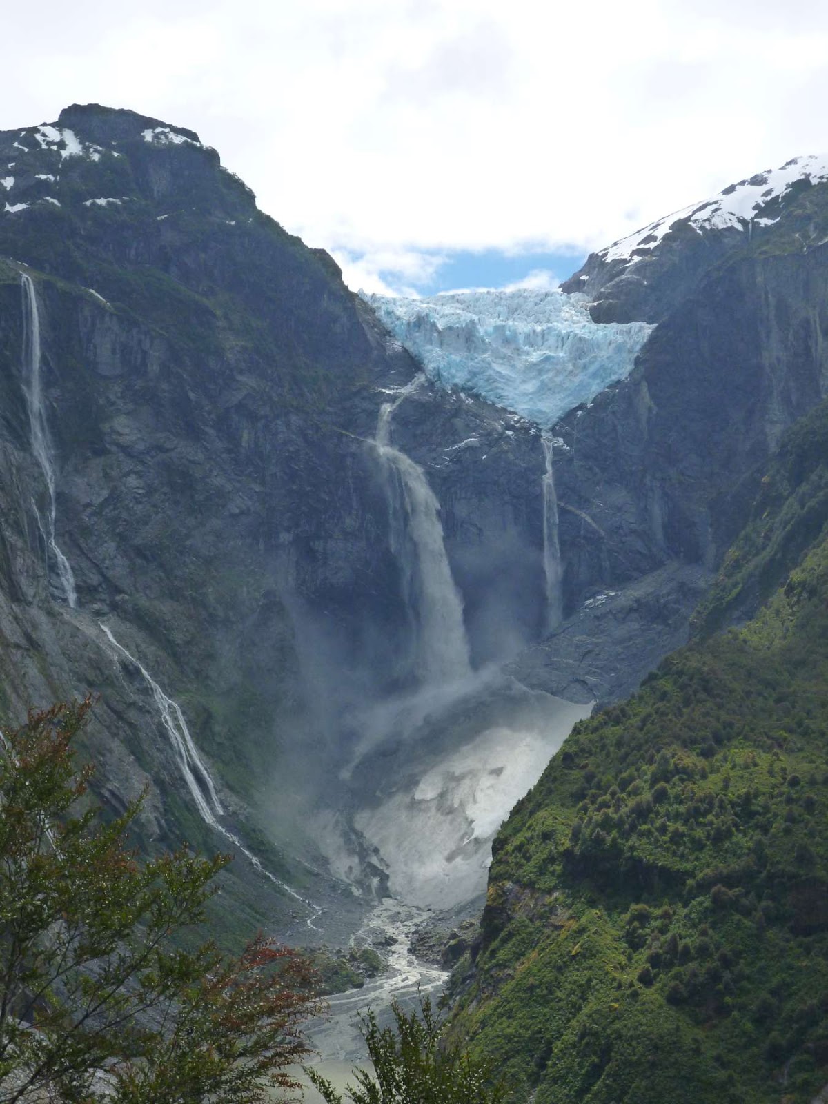
By the time we got to the top our legs were next to useless but nobody cared - we were greeted by a beautiful glacial lake, icebergs bobbing around, and the odd icefall from the hanging glacier above.


Our spirits had been so lifted that we ambitiously decided to try to hitchhike the 118km to Puerto Rio Tranquilo, our next destination. I had taken the strategy of cheerfully saying hola! to everybody and it paid off when a guy I'd met in the local shop offered us a lift. It was freezing as we sped along in the back of the pickup until the guy's dog decided to sit on me, providing extra warmth.


We were taken 40km of the way. When the guy picked us up I had thought that the whole journey was 60km, so we could walk the last 20km if needs be. When we realised that there was another 78km to go Simon looked like he was going to kick me, so I got walking. After many failed hitchhiking attempts we came across an English guy on a bicycle going the opposite way. I am convinced it was the fact that he was wearing a neon orange shirt - the next car that came past stopped and picked us up. The driver even was going all the way to Puerto Rio Tranquilo - un-named English cyclist, you are my hero.

There is one reason to visit Puerto Rio Tranquilo - Las Cavernas de Marmol, the marble caves. Over millions of years, the ice-laden waters of the Rio Tranquilo have carved these amazing caves out of the solid rock.


The colours are so vivid and range from deep-blue to ice-white, with everything in between.


We took a boat tour through the caves and were pretty impressed with the captains skill at navigating into the tiniest of spaces.


There were three others on the boat. A girl from Chile and guys from Canada and Austria. Christian, the Austrian guy, had a car and offered to drive us the 5km back to the village. The only catch was that he was driving to a few lookout points first - this was music to our ears so we jumped in!


On the way back, his car started making a funny noise. It turned out a metal guard had broken and was hanging down, banging across the road. There was only one thing to do - find a massive stick and try to snap it off.


It turned out the really big stick was a part of some one's fence. They did not look impressed. Anyway, after some bending and bashing the metal plate broke off - success!


That was the end of our adventure across the Carretera Austral. We took a bus to the border town of Chile Chico and crossed the border. We were completely screwed over by a Japanese girl who assured us that the distance between the Chilean and Argentinian immigration stations was only one kilometer. It turned out to be 7km and took over an hour- which we walked with all our stuff. To add insult to injury, she overtook us in a taxi halfway along the road. Japanese backpackers have gone down in my estimations.


So I'm back in Argentina! The town of Los Antiguos to be precise. Next stop is the hikers paradise of El Chaltean. Chao for now!

Sitting by the glacial lake at the top of Cerro Castillo I feel a bit peckish so chow down on some genuine glacial ice.


The campground had two little puppies. I spent all my free time teaching them circus tricks. They responded by trying to eat my left shoe.


The trees are alive!

Tuesday, December 11, 2012

Carretera Austral - Part 1

The Carretera Austral - a 1,240km stretch of road, is one of the most ambitious infrastructure projects ever undertaken in Chile. It is also an example of utter stupidity.

In the 1970's General Augusto Pinochet ordered the construction of the road to link many small rural villages and strengthen the Chilean presence in Patagonia -10,000 soldiers were put to the task. The road was to carve a line through Andes mountains, glacial lakes, wetlands and parts of the country that spend half the year under snow. Thirty years, $300m and several lost lives later, the road was mostly finished (although work still continues in some areas). It serves a mere 100,000 people.

It does, however, link some stunningly beautiful areas of Patagonia. Words like "Hanging glaciers", "high-altitude lakes" and "marble caves" were mentioned. It was impossible to resist.

Myself and Simon crossed over the border to Chile and headed to the village of Futaleufu. In a region with high prices and beautiful countryside, pitching a tent is the way to go. Unfortunately, Futaleufu has a population of about 1,000 and most of them hibernate until mid-December so the camping shop was closed. The revised plan was a trip to the local hardware store. A seriously dated two man tent was purchased.


I also acquired what is possibly the thinnest sleeping bag ever made. On the plus side, it is camouflaged - if we get in a firefight with enemy snipers I will probably live longer than Simon.


None of this mattered though because the last time I saw a cloud was in Guatemala. About three seconds after I mentioned that fact it started raining. This side of Patagonia is notorious for wet weather - moisture comes in from the sea and gets pushed up over the mountains, resulting in an average rainfall of 4,000mm for the region.

Even so, we got the tent up and got a fire going to cook up some chorizo - we don't have any cooking implements yet, so had to improvise.


After scouting around our camping site, Simon was overjoyed to find that we had a power source. I think my definition of wilderness camping and Simon's differ slightly.


The tent is ambitiously named Rainforest 2. Unless this relates to the fact that the bamboo sticks come from a rainforest, I cannot see the connection. It does not fare well in the rain. After a wet, cold, windy night I woke up to find that the tent was now in the middle of a large puddle, and most of the puddle was inside my sleeping bag. I began to wonder what I was doing on this side of the Andes.

We went for a hike up to Piedra Aguilla (Eagle Rock). There are spectacular views down into the valley as the river snakes its way through the mountains. There is also a nice little lagoon perched high up on a hill.


Backpacking the Carretera Austral is not for the faint hearted. Although there is a road, there is almost no public transport, so a popular way to get around is by hitchhiking. The only problem with this approach is that you need cars to be going in your direction. And be female. There are no buses out of Futaleufu on Sundays so we attempted to hitchhike out. We failed.


The following day we bussed it to Santa Lucia. We had a four hour wait for the next bus South so we got back on the road to hitchhike instead. In all that time we only saw three cars, and they were going to a construction site around the corner. Another hitchhiking failure.


Four hours later we got on the bus to La Junta, on the way to our actual destination of Puyuhuapi. There are only two buses a week between the two villages and it was too late to hitchhike so we stayed a night in La Junta and got the bus the next day. We headed straight out to Parque Nacional Quelat to see the hanging glacier. The park is 20km from the village so more hitchhiking was in order. Finally, our luck was in and we got a ride most of the way! Wooohooo!

The glacier is dramatically perched on the top of a cliff. It spits out tonnes of ice-cold water and pushes rocks down the cliff as the summer sun melts it away. Every so often a chunk breaks off and crashes down onto the rocks below with a huge thunder-crack that reverberates around the whole park.


Our hitchhiking luck continued on the way back, which was fortunate because we were knackered. We got picked up by some construction workers and spent the journey back sleeping against a drum of bolts used for securing power cables to pylons.


We've just arrived in the town of Coyhaique to stock up on some supplies and plan the next part of the trip. Here are some more pics from the last few days.

There is one camping ground in Puyuhuapi - every tent space has a roof over it. Is this really camping?


This was the view from the campground though, so we were happy enough.


When entering Quelat National park you are greeted with a spectacular picture. It gets better the further you go.


This bridge is constructed of the heaviest wood in the world. It is not surprising that the max load is only four people.


The hanging glacier from the lake below.

Wednesday, December 5, 2012

El Bolson and over the border!

As hippy places go, El Bolson is not very hippy-ish. It is, however, surrounded by snow-capped mountains ripe for climbing!


We found a beautiful place to stay just outside town with large gardens and a log fire. On closer inspection, a big barbecue was discovered. The laws of Argentina dictate that the grilling of a huge piece of meat is required whenever a barbecue is available. 2.2kg between four people seemed a respectable amount.


It took over an hour on the grill but somehow it came out perfect.


The whole thing was consumed in about 43 seconds.


El Bolson is in the middle of a valley lined with Andes mountains. On one side there is the impenetrable rocky wall that separates Argentina from Chile. On the other side some equally rocky stuff is just asking to be climbed. We decided to head up to the top of the snowy peak of Cerro Piltriquitron.


Halfway up we discovered El Bosque Tallado (the carved forest), where local artists showcase sculptures they have carved out of trees from the forest. It was quite good fun and the carvings were spectacular, but I was a bit surprised that anyone would choose 1,500 meters up the side of a mountain as a location to display their art.


The climb started easy enough, with great views across the valley.


Four hours later we made it to the top and were greeted by spectacular views, and even a couple of Condors!


The next day myself and Simon headed off to Esquel on our way across the boarder to the Chilean side of Patagonia. One quirky fact about Patagonia is that a large group of Welsh people settled there in the late 1800's. If you keep your ears pricked up, you can still hear Welsh being spoken in places like Esquel today.


Next up is a detour to a little visited corner of Patagonia on the Chilean side, where transport is scarce and the weather is wet. I'm not really sure what I was thinking. I'll leave you with some pics from the mountain climb.

After getting above the treeline it got cold and snowy. If you look really closely, you can see two hippys in the bottom-left corner of this picture. Some joker had told them the top of the mountain was a light 90 minute stroll. It was actually a strenuous four hour hike. The girl was wearing a dress and the guy had sandals on his feet. They did not enjoy themselves.


Finally, we make it to the summit!


Nice views from the top.


That is Chile in the background. I waved to my friends Consuelo and Carla but I don't think they saw me.